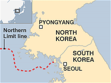
Well apparently nobody who is anybody at the British Broadcasting Corporation reads Monster Island, because in their story today on the naval clash in the Yellow Sea, they used the same stinkin' map.
Doesn't anyone there realize that the three islands to the east of the BBC line are within South Korea's declared maritime borders, not outside of them? (The link above explains in a little more detail what's wrong with the map.)
Geez, fire that drunken Mancunian already! Is the BBC that hard up for fact-checkers on Korea, because I'd be more than happy to take on the work.
Seriously, I expect better from the likes of the BBC (or NPR, PBS, the New York Times, the Los Angeles Times, etc.).

UPDATE:
I just noticed one other problem, not with the map above, but with the New York Times map that I used in my first link: Paengnyŏngdo [백령도, aka Baengnyeongdo] and Taech'ŏngdo [대청도, aka Daecheongdo] are both colored light beige, indicating they are North Korean islands when in fact they are South Korean islands.
Really, this is very sloppy for "the newspaper of record."


It's like Tokdo/Takeshima - honestly, the rest of the world could care less about who a couple rocks belong too. There are a lot more important things to worry about!
ReplyDeleteYou care enough to comment :p
ReplyDelete